
It’s still pretty gloomy outside when we get up. Ick!
Canyonlands National Park is divided into three sections; Island in the Sky, the Needles and the Maze, of which Island in the Sky is the most accessible and also the closest one to Moab.
When we get to the visitor center for Island in the Sky the impending government shutdown is a hot topic. As of this morning things are not looking good.
View from across the road near the visitor center.

We get out for a short walk at Whale Rock, but the wind is so bitingly cold that we turn back after just five minutes. I’m wearing my hiking pants over my Capri tights, a t-shirt over a long-sleeved shirt, my hoodie over my polartec and a bandana to keep my ears warm … can’t think of anything that would be warmer out of the things I have with me. Sandy all bundled up:

We continue all the way to the trailhead for Upheaval Dome and decide to at least walk to the first viewpoint. The second viewpoint isn’t much further, but you have to walk over a rounded section of slickrock with steps cut into the stone where the wind is so bad it approaches gale force and after almost getting blown off a cliff Sandy decided to stay put. Not to be deterred I struggle all the way to the second viewpoint, only to find it really adds nothing to the first. Oh well.

Next up is the Green River overlook, except it's not really an overlook in that you can’t see very far between it being overcast and the fog.

The Grand View Point is supposed to be the real gem, where on a clear day you can see all the way to the Needles district of the park. Of course I can barely see where I’m going, let alone some faraway section of the park, but I think in this instance it adds something to the picture … kind of mysterious.

Not sure where I took this picture.

Sandy asked me to take a picture of the wood dividers. She really, really wants a piece for in the yard, but of course it’s impractical, not to mention five-years-in-jail-illegal to take wood from a national park.

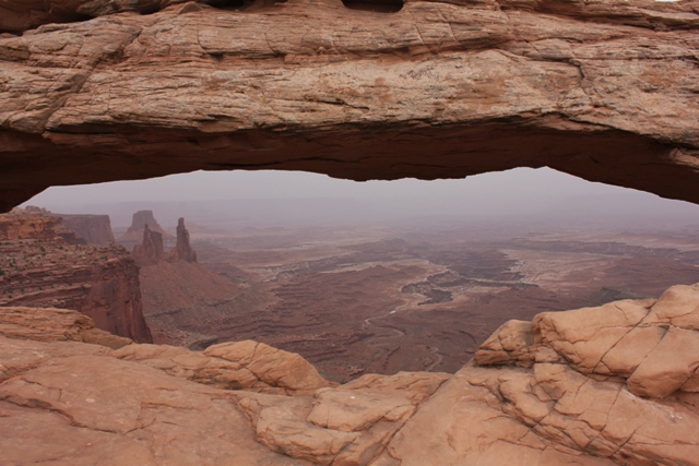
Arches may have more arches than any other National Park, but Canyonlands has a very nice arch of its own: Mesa Arch.

Again, on a clear day the view through the arch would be astounding, but it’s a little limited here.
On the way back to the visitor center a watery sun breaks through the clouds. Hooray! It’s not warm and really, not very sunny either, but it looks a bit warmer at least. Now if only the fog would lift!

We stop to check out the infamous Shafer Trail. Sandy says it is comparable to the section of route 66 we drove last year, but after pointing out that a) it’s a dirt road, b) it’s a dirt road with questionable sections, and 3) there are no guard rails on any of the razor sharp turns … she agrees that this is even worse. Scary stuff!

It’s strange leaving Canyonlands knowing this might be the last National Park we visit on this trip.
Before returning to Moab we visit Dead Horse Point State Park. First we watch a short introductory movie at the visitor center, then we check out the viewpoints near the road. Here is the left side of the Dead Horse Point overlook.

Finally, the right with the famous Gooseneck in the Colorado River 2000 feet below.

Not wanting to leave without seeing any of the less accessible viewpoints we start out towards Meander overlook, only to realize half way that it’s taking us to the one we were able to see from the road.
Pinyon Pine.

I'm a huge grass fanatic. I don’t know why, but I really love all different kinds of grass so this fuzzy kind caught my eye.

Not daunted by our earlier mishap we decide to watch the sunset at the Rim overlook. There’s a sign stating 2 miles to Point and it’s 7pm so Sandy figures she won’t make it in time and that it’s better for me to go ahead by myself.
Now signage at this park is not the best and I’m jogging along as fast as I can when I miss the turn off for the Rim overlook. It does seem like quite the distance, but I keep pushing myself on until I reach a sign saying Shafer Canyon overlook 0.5mi. Shafer Canyon?? Wasn’t that one after the Rim overlook? Yep!
Since I really don’t know the one overlook from the other I make a split second decision to keep running and at least get to see one of them. It’s pretty nice, but running in over uneven surface at an altitude of 5000 feet up and over slickrock is not for the faint of heart. I run as much as I can with short walking breaks in between where the sand is too deep, or the slope to steep.
That is when I spot the turn off for Rim Overlook. I want so badly to just keep going, but I’m not sure if Sandy stayed behind or decided to walk as far as possible so I have no option but to run all the way down to the Rim Overlook too. Of course Sandy’s not there.
The little watery sun has now set and with the cloud cover it’s starting to get dark quickly. I know I should be able to make it to the trailhead in time, but I still haven’t found Sandy and I’m a little bit worried she took a wrong turn. The trails here are marked only by cairns (small piles of stones stacked on top of each other) and it would be impossible to make it out once daylight’s gone.
I run, and run, and run some more and then luckily I find Sandy (who did in fact make it to the Rim Overlook, but since she wasn’t sure where I was decided to head back). I promise next time we’ll be clearer about where to meet back up and stuff.
Because I never get tired of climbing things; me in a tree.

Back at the visitor center where we parked the car I spot this little stone with a real dino track. How neat!

We just barely make it back to the campground before 9pm. The other cabin we had was only available for the first two nights so today we have to check in again to get the key to our new cabin. It’s smaller and more basic, but still pretty cute. I’ve really enjoyed staying here!
For dinner we headed to Pasta Jay’s where Sandy gets her gnocchi fix and I try a pesto chicken tortellini.
Total miles for today: have to check
Hotel: Moab Valley RV Resort
Restaurant: Pasta Jay’s
Hotel: Moab Valley RV Resort
Restaurant: Pasta Jay’s
Till now I only marvelled at the wonderfull landscapes and rock formations, butt all of a sudden something hit me.
Wasn't this like the West was won????????????
Maybe it's the gloomy weather, but real people crossed this landscape.
Hole families with children , horsecarts or oxen, no roads, no maps, looking for a better life. struggling up a mountain, finally getting there, hoping for green pastures just to find an other mountain or a roaring river or a Mars like landscape. Were they ignorant fools or despered people who had nothing to loose,looking for a new future.
If I look at Shafer Trail, I think about the first pioneers that took that pass when there was no trail at all, awsome!!!!!!!!!!!!!!!!!!!!!
I imagine them, reaching Meander look. Just standing there, completly devastated at the sight, and wondering how on earth they were going to cross those rocks and that river. Pioneers to me, were the people who stole the land from the Indians or Rawhide or Bonanza like caracters. Simplistic isn't it. Your trip made them come alive for me. Inspite of what they did to the Indians, I think they were very brave.
Last line, the picture with you in the tree looks like it has been photoshoped, as if the tree is added later. Eerie (is that an existing word)
Lots of love,and take care xxxxxxxxxxxx Joeve